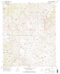
1967 Map of Bloody Basin
USGS Topo · Published 1976About this map
TI Ranch and the LX Bar Ranch serve as central points of habitation within this mid-century survey of the high desert terrain. The landscape is defined by the expansive Bloody Basin and the prominence of Turret Peak to the northwest. This area shows a functional ranching economy dependent on a network of water sources, including the Monroe Canyon Windmill, Danes Dam, and numerous tanks such as Javelina Tank and Night Trap Tank.
Find a feature on this map
81 named features on this map. Tap any name to fly to it.
Don’t see what you’re looking for? This feature index may not catch every label — zoom into the map to look around manually.
Map Details
Editions of this 1967 Bloody Basin Map
2 editions found
Other maps of this area

1887 · Verde
USGS Topo · 1:250,000

1892 · Verde
USGS Topo · 1:250,000

1929 · Turret Peak
USGS Topo · 1:125,000

1933 · Turret Peak
USGS Topo · 1:125,000

1954 · Holbrook
USGS Topo · 1:250,000

1957 · Holbrook
USGS Topo · 1:250,000

1958 · Holbrook
USGS Topo · 1:250,000

1960 · Holbrook
USGS Topo · 1:250,000
1967 · Brooklyn Peak
USGS Topo · 1:24,000
1967 · Chalk Mountain
USGS Topo · 1:24,000