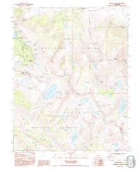
1990 Map of Bloody Mountain
USGS Topo · Published 1995About this map
The mining heritage of the Sierra Nevada is clearly etched across this landscape, centered on the Mill City (Site) and the high-altitude industrial remains along Mammoth Creek. Multiple workings, including the Old Mammoth Mine, Monte Cristo Mine, and the Mammoth Consolidated Mine, reflect a period of intensive subterranean exploration beneath the towering Mammoth Rock. These sites are clustered near the Cold Water Campground, suggesting a transition from industrial exploitation to the modern recreational economy that defines the region today.
Find a feature on this map
68 named features on this map. Tap any name to fly to it.
Don’t see what you’re looking for? This feature index may not catch every label — zoom into the map to look around manually.
Map Details
Editions of this 1990 Bloody Mountain Map
This is the sole edition of this map. No revisions or reprints were ever made.
Other maps of this area

1901 · Mt. Lyell
USGS Topo · 1:125,000

1904 · Kaiser
USGS Topo · 1:125,000

1912 · Mt. Goddard
USGS Topo · 1:125,000

1914 · Mt. Morrison
USGS Topo · 1:125,000

1947 · Mariposa
USGS Topo · 1:250,000

1948 · Mariposa
USGS Topo · 1:250,000

1953 · Mt. Morrison
USGS Topo · 1:62,500

1953 · Mt Abbot
USGS Topo · 1:62,500

1953 · Devils Postpile
USGS Topo · 1:62,500

1953 · Kaiser Peak
USGS Topo · 1:62,500