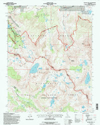
1994 Map of Bloody Mtn.
USGS Topo · Published 1997About this map
Old Mammoth Mine and the Pine City area anchor the northern reaches of this high-altitude landscape, where the legacy of late-19th-century extraction is preserved at the Mammoth Consolidated Mine Interpretive Site. The terrain is defined by the sharp divide of the Mammoth Crest, separating the watershed of Lake Mary and its alpine neighbors from the Cascade Valley. As of the mid-1990s, this area reflects a complex transition from its industrial past to a protected wilderness, as evidenced by the former Mill City (Site) and a lone Grave sitting near a Motocross Track.
Find a feature on this map
69 named features on this map. Tap any name to fly to it.
Don’t see what you’re looking for? This feature index may not catch every label — zoom into the map to look around manually.
Map Details
Editions of this 1994 Bloody Mtn. Map
This is the sole edition of this map. No revisions or reprints were ever made.
Other maps of this area

1901 · Mt. Lyell
USGS Topo · 1:125,000

1904 · Kaiser
USGS Topo · 1:125,000

1912 · Mt. Goddard
USGS Topo · 1:125,000

1914 · Mt. Morrison
USGS Topo · 1:125,000

1947 · Mariposa
USGS Topo · 1:250,000

1948 · Mariposa
USGS Topo · 1:250,000

1953 · Mt. Morrison
USGS Topo · 1:62,500

1953 · Mt Abbot
USGS Topo · 1:62,500

1953 · Devils Postpile
USGS Topo · 1:62,500

1953 · Kaiser Peak
USGS Topo · 1:62,500