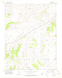
1972 Map of Bloom
USGS Topo · Published 1976About this map
The Atchison Topeka and Santa Fe railroad cuts diagonally across this high plains landscape, anchoring the small settlements of Bloom and Mindeman in the early 1970s. The region is defined by a complex network of intermittent water sources and drainage systems, including the South Timpas Creek, Iron Springs Arroyo, and the various branches of the Bear Springs Arroyo.
Find a feature on this map
44 named features on this map. Tap any name to fly to it.
Don’t see what you’re looking for? This feature index may not catch every label — zoom into the map to look around manually.
Map Details
Editions of this 1972 Bloom Map
3 editions found
Other maps of this area

1891 · Timpas
USGS Topo · 1:125,000

1891 · Apishapa
USGS Topo · 1:125,000

1893 · Apishapa
USGS Topo · 1:125,000

1894 · Timpas
USGS Topo · 1:125,000

1897 · Apishapa
USGS Topo · 1:125,000

1954 · Trinidad
USGS Topo · 1:250,000

1955 · La Junta
USGS Topo · 1:250,000

1955 · Trinidad
USGS Topo · 1:250,000

1958 · La Junta
USGS Topo · 1:250,000

1958 · Trinidad
USGS Topo · 1:250,000