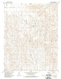
1979 Map of Bloom SE
USGS Topo · Published 1986About this map
The townships of Appleton and Center anchor this 1970s landscape in Clark County, defined by a branching drainage system that feeds the region's cattle and farming operations. The terrain is intricately carved by several waterways, including Bluff Creek in the northeast and the confluence of the West Branch Bear Creek and East Branch Bear Creek further south. These creek beds and various unnamed springs provided critical water sources for the early ranching era, while the presence of a diagonal Pipeline through the territory marks the mid-century infrastructure expansion into the Great Plains. The map's fine contour lines reveal a complex network of draws and breaks, such as those surrounding Hackberry Creek, showing the transition from flat upland plains to the more dissected valley floors that were essential for sheltered homesteading.
Find a feature on this map
9 named features on this map. Tap any name to fly to it.
Don’t see what you’re looking for? This feature index may not catch every label — zoom into the map to look around manually.
Map Details
Editions of this 1979 Bloom SE Map
2 editions found
Other maps of this area

1894 · Sitka
USGS Topo · 1:62,500

1896 · Ashland
USGS Topo · 1:125,000

1955 · Pratt
USGS Topo · 1:250,000

1959 · Pratt
USGS Topo · 1:250,000

1967 · Bloom
USGS Topo · 1:24,000

1972 · Ashland NW
USGS Topo · 1:24,000
1972 · Ashland
USGS Topo · 1:24,000

1979 · Sitka
USGS Topo · 1:24,000

1979 · Bloom SE
USGS Topo · 1:24,000
1979 · Simmons Creek
USGS Topo · 1:24,000