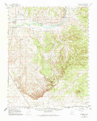
1960 Map of Bloomfield
USGS Topo · Published 1985About this map
Bloomfield serves as the focal point for this 1960s study of the high desert landscape, where the San Juan River and the Citizens Ditch provide a stark contrast to the surrounding mesas. The area reflects a significant mid-century industrial presence, marked by multiple natural gas facilities including the Angel Peak Compressor Sta and the West Kutz Canyon Compression Station. Pipelines crisscross the terrain, following the contours of Kutz Canyon and Cañon Largo, illustrating the region's role in energy infrastructure.
Find a feature on this map
38 named features on this map. Tap any name to fly to it.
Don’t see what you’re looking for? This feature index may not catch every label — zoom into the map to look around manually.
Map Details
Editions of this 1960 Bloomfield Map
3 editions found

Other maps of this area

1889 · Largo
USGS Topo · 1:250,000

1889 · Chaco
USGS Topo · 1:250,000

1892 · Chaco
USGS Topo · 1:250,000

1895 · Largo
USGS Topo · 1:250,000

1954 · Shiprock
USGS Topo · 1:250,000

1954 · Aztec
USGS Topo · 1:250,000

1958 · Shiprock
USGS Topo · 1:250,000

1958 · Aztec
USGS Topo · 1:250,000

1959 · Shiprock
USGS Topo · 1:250,000

1959 · Gould Pass
USGS Topo · 1:62,500