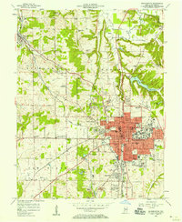
1956 Map of Bloomington
USGS Topo · Published 1958About this map
Bloomington serves as the focal point for this mid-century Indiana study, showing a community defined by its university surroundings and heavy industrial roots. The landscape is marked by numerous Quarry sites concentrated in the limestone-rich corridor between the city and Ellettsville. Transportation is anchored by the Monon and Illinois Central Railroad, which crisscross the terrain to service these industrial hubs. Cultural and civic life is represented through a dense network of neighborhood schools like Fairview Sch and Rogers Sch, alongside community spaces like the County Fairgrounds and Bryan Park. To the north and west, the terrain becomes more rural, punctuated by family cemeteries such as Armstrong Cem and Wampler Cem. The mapping of Griffy Reservoir and University Lake highlights the infrastructure required for the growing town, while Camp Wapehani and various radio towers on the city's periphery signal the mid-century expansion into Perry and Van Buren townships.
Find a feature on this map
70 named features on this map. Tap any name to fly to it.
Don’t see what you’re looking for? This feature index may not catch every label — zoom into the map to look around manually.
Map Details
Editions of this 1956 Bloomington Map
This is the sole edition of this map. No revisions or reprints were ever made.
Other maps of this area

1908 · Bloomington
USGS Topo · 1:48,000

1910 · Bloomington
USGS Topo · 1:62,500

1942 · Franklin
USGS Topo · 1:125,000

1947 · Allens Creek
USGS Topo · 1:24,000

1947 · Unionville
USGS Topo · 1:24,000

1947 · Gosport
USGS Topo · 1:24,000

1948 · Hindustan
USGS Topo · 1:24,000

1950 · Gosport
USGS Topo · 1:24,000

1953 · Indianapolis
USGS Topo · 1:250,000

1956 · Indianapolis
USGS Topo · 1:250,000