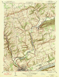
1947 Map of Bloomsburg
USGS Topo · Published 1947About this map
Bloomsburg sits at the southern edge of this mid-century survey, defined by its position along the Susquehanna River and the winding course of Fishing Creek. The town serves as a regional hub, anchored by the State Teachers College and an industrial presence signaled by the Paper Mill and the Irondale Dam upstream. Transport networks dominate the valley, with the Delaware Lackawanna and Western railroad paralleling the river and the Reading line following the creek through the ridge gaps.
Find a feature on this map
45 named features on this map. Tap any name to fly to it.
Don’t see what you’re looking for? This feature index may not catch every label — zoom into the map to look around manually.
Map Details
Editions of this 1947 Bloomsburg Map
2 editions found
Other maps of this area

1889 · Catawissa
USGS Topo · 1:62,500

1892 · Catawissa
USGS Topo · 1:62,500

1892 · Shamokin
USGS Topo · 1:62,500

1893 · Shamokin
USGS Topo · 1:62,500

1894 · Catawissa
USGS Topo · 1:62,500

1894 · Bloomsburg
USGS Topo · 1:62,500

1935 · Hughesville
USGS Topo · 1:62,500

1943 · Shamokin
USGS Topo · 1:62,500

1947 · Bloomsburg
USGS Topo · 1:24,000

1947 · Stillwater
USGS Topo · 1:24,000
Featured Places
- Bloomsburg, PA
- Greenwood Township, PA
- North Centre Township, PA
- Lightstreet, Scott Township
- Orangeville, PA