2023 Map of Bloomsbury
USGS Topo · Published 2023About this map
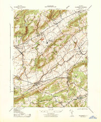
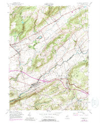
The Musconetcong River and Pohatcong Creek systems carve out distinct valleys in this region of Western New Jersey, creating a landscape defined by parallel ridges like Pohatcong Mountain. The historical infrastructure of the Morris Canal remains visible near New Village, tracing the industrial heritage of the nineteenth-century corridor. In the south, the village of Bloomsbury serves as a focal point near the Warren and Hunterdon County line, where the topography shifts into the Musconetcong Valley. Local history is anchored by landmarks such as the Greenwich Presbyterian Church and its adjacent Cemetery, while modern utility is represented by the Warren County Community College and small regional landing strips like Parker Airport and Jugtown Mountain Airport. Small hamlets such as Kennedy Mills and West Portal dot the landscape, illustrating the persistent small-town character of the Musconetcong Highlands.
Find a feature on this map
152 named features on this map. Tap any name to fly to it.
Don’t see what you’re looking for? This feature index may not catch every label — zoom into the map to look around manually.
Map Details
Editions of this 2023 Bloomsbury Map
This is the sole edition of this map. No revisions or reprints were ever made.
Historical Maps of Kennedy Mills Through Time
3 maps found