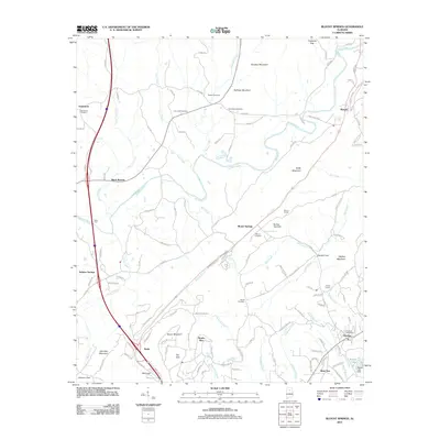
2011 Map of Blount Springs
USGS Topo · Published 2011About this map
Blount Springs and the surrounding Blount County hills are defined by a complex network of creeks and ridges that follow the southwest-to-northeast grain of the Appalachians. The Mulberry Fork serpentines through the northern half of the landscape, while the southern reaches are marked by newer residential developments such as Smoke Rise and Bent Tree. For genealogists, the map is a significant record of local families and congregations, preserving the locations of the Damascus Cemetery, Union Hill Cemetery, Tedder Cemetery, and Harrell Cemetery. The transport infrastructure is anchored by the historic Blount Tunnel and the small town of Hayden, where the Hayden Post Office serves the community. From the summit of Hayden Mountain to the depths of The Sink, this survey documents a transition from traditional agricultural and mining landscapes to modern residential expansion near the turn of the 21st century.
Find a feature on this map
129 named features on this map. Tap any name to fly to it.
Don’t see what you’re looking for? This feature index may not catch every label — zoom into the map to look around manually.
Map Details
Editions of this 2011 Blount Springs Map
This is the sole edition of this map. No revisions or reprints were ever made.
Other maps of this area

1888 · Cullman
USGS Topo · 1:125,000

1889 · Birmingham
USGS Topo · 1:125,000

1892 · Cullman
USGS Topo · 1:125,000

1892 · Birmingham
USGS Topo · 1:125,000

1895 · Birmingham
USGS Topo · 1:125,000

1907 · Birmingham
USGS Topo · 1:125,000

1951 · Arkadelphia
USGS Topo · 1:24,000

1951 · Warrior
USGS Topo · 1:24,000
1951 · Creel
USGS Topo · 1:24,000

1951 · Blount Springs
USGS Topo · 1:24,000