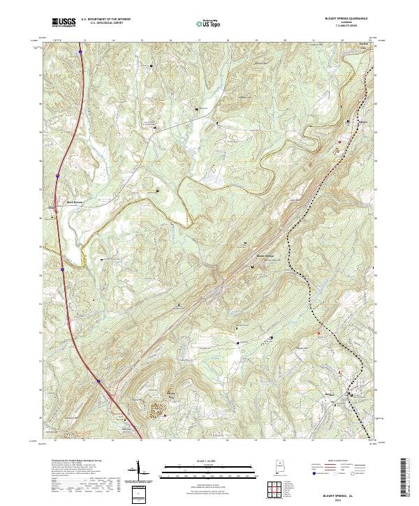
2024 Map of Blount Springs
USGS Topo · Published 2024About this map
The Mulberry Fork carves a deep path through this section of the Cumberland Plateau, serving as the natural boundary between Cullman and Blount counties. The landscape is defined by its ridge-and-valley topography, featuring prominent elevations such as Barefoot Mtn, Huffman Mtn, and Hayden Mtn. For genealogists, the map is particularly valuable for its density of small family and community burial grounds, including the Self Family Cem, Tedder Cem, and Ashley Cem, as well as the larger Hayden Cem-Northwest and Hayden Cem-Southeast.
Find a feature on this map
146 named features on this map. Tap any name to fly to it.
Don’t see what you’re looking for? This feature index may not catch every label — zoom into the map to look around manually.
Map Details
Editions of this 2024 Blount Springs Map
This is the sole edition of this map. No revisions or reprints were ever made.
Other maps of this area

1888 · Cullman
USGS Topo · 1:125,000

1889 · Birmingham
USGS Topo · 1:125,000

1892 · Cullman
USGS Topo · 1:125,000

1892 · Birmingham
USGS Topo · 1:125,000

1895 · Birmingham
USGS Topo · 1:125,000

1907 · Birmingham
USGS Topo · 1:125,000

1951 · Arkadelphia
USGS Topo · 1:24,000

1951 · Warrior
USGS Topo · 1:24,000
1951 · Creel
USGS Topo · 1:24,000

1951 · Blount Springs
USGS Topo · 1:24,000