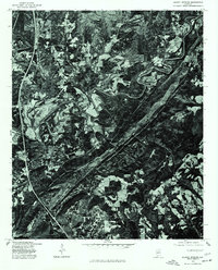
1975 Map of Blount Springs
USGS Topo · Published 1977About this map
Mulberry Fork winds through the heart of this landscape, its tight meanders carving a distinct path through the forested terrain of Blount County. This 1975 orthophotoquad, produced by the U.S. Geological Survey in cooperation with the Soil Conservation Service, provides a detailed aerial perspective of the region's agricultural and timber patterns. The settlement of Blount Springs is visible alongside the more concentrated residential layout of Hayden. Unlike traditional topographic maps, this imagery-based study captures the exact footprint of farm clearings and the density of the woods at the height of the 1970s. The visual contrast between the dark, timbered ridges and the lighter, cleared bottomlands along the river reveals the historical relationship between the local geography and the primary land use of the era.
Find a feature on this map
3 named features on this map. Tap any name to fly to it.
Don’t see what you’re looking for? This feature index may not catch every label — zoom into the map to look around manually.
Map Details
Editions of this 1975 Blount Springs Map
This is the sole edition of this map. No revisions or reprints were ever made.
Other maps of this area

1888 · Cullman
USGS Topo · 1:125,000

1889 · Birmingham
USGS Topo · 1:125,000

1892 · Cullman
USGS Topo · 1:125,000

1892 · Birmingham
USGS Topo · 1:125,000

1895 · Birmingham
USGS Topo · 1:125,000

1907 · Birmingham
USGS Topo · 1:125,000

1951 · Arkadelphia
USGS Topo · 1:24,000

1951 · Warrior
USGS Topo · 1:24,000
1951 · Creel
USGS Topo · 1:24,000

1951 · Blount Springs
USGS Topo · 1:24,000