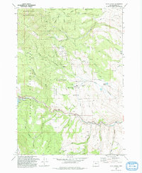
1993 Map of Blue Canyon
USGS Topo · Published 1993About this map
Auburn (Site) serves as a central historical anchor in this rugged portion of the Whitman National Forest, representing a locale with deep ties to Oregon's mining past. The landscape is defined by the sharp descent from Elkhorn Ridge toward the Powder River, where the infrastructure of the Mason Dam has transformed the valley into Phillips Lake. Evidence of earlier settlement and industry is scattered throughout the drainages, including the Malloy Cabin (Ruin) and various unmarked Mine and Quarry sites. This 1993 revision details a complex water management system featuring the Baker City Watershed, several Ditch lines, and a Municipal Aqueduct. The area also functions as the Elkhorn Wildlife Area, balancing its historical mining and timber footprint with modern conservation efforts near the Elkhorn Feeding Station.
Find a feature on this map
52 named features on this map. Tap any name to fly to it.
Don’t see what you’re looking for? This feature index may not catch every label — zoom into the map to look around manually.
Map Details
Editions of this 1993 Blue Canyon Map
This is the sole edition of this map. No revisions or reprints were ever made.
Other maps of this area

1901 · Baker City
USGS Topo · 1:125,000

1901 · Sumpter
USGS Topo · 1:125,000

1955 · Baker
USGS Topo · 1:250,000

1955 · Canyon City
USGS Topo · 1:250,000

1959 · Baker
USGS Topo · 1:250,000

1959 · Canyon City
USGS Topo · 1:250,000

1967 · Baker
USGS Topo · 1:24,000

1967 · Dooley Mtn
USGS Topo · 1:24,000

1967 · Blue Canyon
USGS Topo · 1:24,000
1967 · Bowen Valley
USGS Topo · 1:24,000