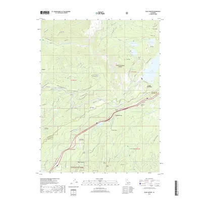
2018 Map of Blue Canyon
USGS Topo · Published 2018About this map
Emigrant Gap and the Tahoe National Forest anchor this survey of the high Sierras, where water management and transportation infrastructure dominate the landscape. The intricate network of the Upper Boardman Canal, Yuba Canal, and Drum Canal illustrates the historical engineering required to move water across these mountain ridges, feeding into the Drum Forebay. Evidence of mid-century industrial activity and modern recreation exist side-by-side, from the Zion Hill Tunnel and Last Chance Mine Rd to the numerous Nordic ski trails such as Twice-is-Nice Nordic. The settlement at Blue Canyon sits near the Blue Canyon - Nyack Airport, while the northern reaches of the map are defined by the high-elevation waters of Lake Spaulding and Rucker Lake. High points like Clyde Mtn and Zion Hill look down upon the South Yuba River, marking a terrain defined by steep ravines and vital transit corridors.
Find a feature on this map
83 named features on this map. Tap any name to fly to it.
Don’t see what you’re looking for? This feature index may not catch every label — zoom into the map to look around manually.
Map Details
Editions of this 2018 Blue Canyon Map
This is the sole edition of this map. No revisions or reprints were ever made.
Other maps of this area

1891 · Colfax
USGS Topo · 1:125,000

1892 · Colfax
USGS Topo · 1:125,000

1894 · Colfax
USGS Topo · 1:125,000

1898 · Colfax
USGS Topo · 1:125,000

1900 · Colfax
USGS Topo · 1:125,000

1902 · Colfax
USGS Topo · 1:125,000

1938 · Colfax
USGS Topo · 1:125,000
1949 · Alleghany
USGS Topo · 1:24,000
1950 · Colfax
USGS Topo · 1:62,500
1950 · Dutch Flat
USGS Topo · 1:24,000