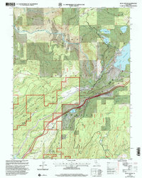
2000 Map of Blue Canyon
USGS Topo · Published 2003About this map
The Sierra Nevada high country at Blue Canyon is a landscape defined by historic transit corridors and deep-canyon resource extraction. The Southern Pacific railroad and the Emigrant Trail converge near Nyack, marking a vital mountain pass. Evidence of the region’s mining heritage is visible in the clusters of claims north of the South Fork Yuba River, including the Mountain View Mine and the Eagle Bird Mine. The map reveals a complex water management system of flumes and canals feeding into Lake Spaulding and the Fuller Lake Spillway, supporting the hydroelectric infrastructure at Camp Spaulding. From the Emigrant Gap Historical Marker to the remote settlement of Omega, this survey details the intersection of early pioneer routes and modern transportation engineering.
Find a feature on this map
66 named features on this map. Tap any name to fly to it.
Don’t see what you’re looking for? This feature index may not catch every label — zoom into the map to look around manually.
Map Details
Editions of this 2000 Blue Canyon Map
This is the sole edition of this map. No revisions or reprints were ever made.
Other maps of this area

1891 · Colfax
USGS Topo · 1:125,000

1892 · Colfax
USGS Topo · 1:125,000

1894 · Colfax
USGS Topo · 1:125,000

1898 · Colfax
USGS Topo · 1:125,000

1900 · Colfax
USGS Topo · 1:125,000

1902 · Colfax
USGS Topo · 1:125,000

1938 · Colfax
USGS Topo · 1:125,000
1949 · Alleghany
USGS Topo · 1:24,000
1950 · Colfax
USGS Topo · 1:62,500
1950 · Dutch Flat
USGS Topo · 1:24,000