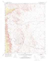
1952 Map of Blue Diamond
USGS Topo · Published 1970About this map
The Blue Diamond mining settlement and its surrounding industrial and ranching landscape anchor this 1950s study. The Blue Diamond Mine and nearby Sandstone Quarry demonstrate the early extraction economy of the region, while the Union Pacific Road provides the critical rail link for shipping materials across the high desert. Settlement is concentrated at small outposts like Wheeler Camp Spring and the Oliver Ranch, illustrating how water sources dictated human activity.
Find a feature on this map
40 named features on this map. Tap any name to fly to it.
Don’t see what you’re looking for? This feature index may not catch every label — zoom into the map to look around manually.
Map Details
Editions of this 1952 Blue Diamond Map
5 editions found
Other maps of this area

1907 · Las Vegas
USGS Topo · 1:250,000

1908 · Las Vegas
USGS Topo · 1:250,000

1910 · Ivanpah
USGS Topo · 1:250,000

1912 · Ivanpah
USGS Topo · 1:250,000

1942 · Ivanpah
USGS Topo · 1:250,000

1947 · Kingman
USGS Topo · 1:250,000

1948 · Kingman
USGS Topo · 1:250,000

1952 · Corn Creek Springs
USGS Topo · 1:62,500

1952 · Gass Peak
USGS Topo · 1:62,500

1952 · Blue Diamond
USGS Topo · 1:62,500