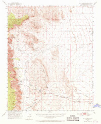
1952 Map of Blue Diamond
USGS Topo · Published 1970About this map
The eastern slopes of the Spring Mountains dominate this 1950s landscape, where industrial extraction meets early desert settlement. The company town of Blue Diamond serves as the focal point for local activity, supported by the Blue Diamond Mine and a dedicated spur of the Blue Diamond Union Pacific Railroad. This rail line and the presence of numerous quarries and a Sandstone Quarry indicate a desert economy deeply tied to the land's mineral resources.
Find a feature on this map
31 named features on this map. Tap any name to fly to it.
Don’t see what you’re looking for? This feature index may not catch every label — zoom into the map to look around manually.
Map Details
Editions of this 1952 Blue Diamond Map
5 editions found
Other maps of this area

1907 · Las Vegas
USGS Topo · 1:250,000

1908 · Las Vegas
USGS Topo · 1:250,000

1910 · Ivanpah
USGS Topo · 1:250,000

1912 · Ivanpah
USGS Topo · 1:250,000

1942 · Ivanpah
USGS Topo · 1:250,000

1947 · Kingman
USGS Topo · 1:250,000

1948 · Kingman
USGS Topo · 1:250,000

1952 · Corn Creek Springs
USGS Topo · 1:62,500

1952 · Gass Peak
USGS Topo · 1:62,500

1952 · Blue Diamond
USGS Topo · 1:62,500