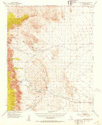
1952 Map of Blue Diamond
USGS Topo · Published 1953About this map
Blue Diamond sits at the base of Blue Diamond Hill in this early 1950s survey of Clark County, documenting a landscape where industrial mining and traditional ranching coexist. The map details the operations of the Blue Diamond Mine and nearby Sandstone Quarry, alongside essential water sources such as Mormon Green Springs and Wheeler Camp Spring. The presence of the Bar Nothing Ranch and Oliver Ranch indicates the late-stage ranching economy before the rapid suburban expansion of nearby Las Vegas. Transport is dominated by the Union Pacific Road corridor to the south, while the western portion of the sheet is preserved as part of the Desert Game National Range, encompassing the dramatic verticality of the Spring Mountain Range and Red Rock Canyon. This topographic study captures a critical water-dependent network of springs, such as Willow Spring and Cottonwood Springs, which dictated settlement patterns in the arid terrain.
Find a feature on this map
36 named features on this map. Tap any name to fly to it.
Don’t see what you’re looking for? This feature index may not catch every label — zoom into the map to look around manually.
Map Details
Editions of this 1952 Blue Diamond Map
5 editions found
Other maps of this area

1907 · Las Vegas
USGS Topo · 1:250,000

1908 · Las Vegas
USGS Topo · 1:250,000

1910 · Ivanpah
USGS Topo · 1:250,000

1912 · Ivanpah
USGS Topo · 1:250,000

1942 · Ivanpah
USGS Topo · 1:250,000

1947 · Kingman
USGS Topo · 1:250,000

1948 · Kingman
USGS Topo · 1:250,000

1952 · Corn Creek Springs
USGS Topo · 1:62,500

1952 · Gass Peak
USGS Topo · 1:62,500

1952 · Blue Diamond
USGS Topo · 1:62,500