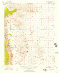
1952 Map of Blue Diamond
USGS Topo · Published 1958About this map
Spring Mountains and the arid expanse west of Las Vegas dominate this 1950s survey, capturing the region's early mining and ranching identity. The settlement of Blue Diamond sits at the heart of the landscape, defined by its namesake Blue Diamond Mine and a network of water sources essential for desert survival, including Wheeler Camp Spring and Cottonwood Spring. The map documents a period of transition, where working landscapes like the Sandstone Quarry and Bar Nothing Ranch coexist with the designated natural space of Red Rock Canyon State Park. Significant industrial infrastructure is recorded by the Union Pacific Railroad (Abandoned) and the Blue Diamond Road, tracing the movement of minerals through the Cottonwood Valley. From the heights of La Madre Mountain to the depths of Red Rock Wash, the map provides a precise record of the springs and ranches, such as the Oliver Ranch, that once sustained this Mojave Desert outpost.
Find a feature on this map
37 named features on this map. Tap any name to fly to it.
Don’t see what you’re looking for? This feature index may not catch every label — zoom into the map to look around manually.
Map Details
Editions of this 1952 Blue Diamond Map
5 editions found
Other maps of this area

1907 · Las Vegas
USGS Topo · 1:250,000

1908 · Las Vegas
USGS Topo · 1:250,000

1910 · Ivanpah
USGS Topo · 1:250,000

1912 · Ivanpah
USGS Topo · 1:250,000

1942 · Ivanpah
USGS Topo · 1:250,000

1947 · Kingman
USGS Topo · 1:250,000

1948 · Kingman
USGS Topo · 1:250,000

1952 · Corn Creek Springs
USGS Topo · 1:62,500

1952 · Gass Peak
USGS Topo · 1:62,500

1952 · Blue Diamond
USGS Topo · 1:62,500