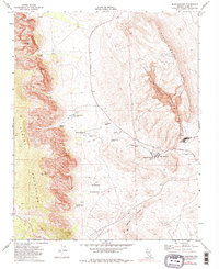
1972 Map of Blue Diamond
USGS Topo · Published 1984About this map
Spring Mountain Ranch and the nearby Bonnie Springs settlement are established outposts on this 1970s landscape, positioned between the high Spring Mountains and the lower Blue Diamond Hills. The local economy is defined by the Blue Diamond Mine, which utilizes a Tramway for transporting materials across the desert floor toward the Union Pacific railroad line.
Find a feature on this map
34 named features on this map. Tap any name to fly to it.
Don’t see what you’re looking for? This feature index may not catch every label — zoom into the map to look around manually.
Map Details
Editions of this 1972 Blue Diamond Map
3 editions found
Other maps of this area

1907 · Las Vegas
USGS Topo · 1:250,000

1908 · Las Vegas
USGS Topo · 1:250,000

1910 · Ivanpah
USGS Topo · 1:250,000

1912 · Ivanpah
USGS Topo · 1:250,000

1942 · Ivanpah
USGS Topo · 1:250,000

1947 · Kingman
USGS Topo · 1:250,000

1948 · Kingman
USGS Topo · 1:250,000

1952 · Blue Diamond
USGS Topo · 1:62,500

1954 · Las Vegas
USGS Topo · 1:250,000

1954 · Kingman
USGS Topo · 1:250,000