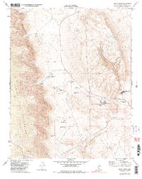
1972 Map of Blue Diamond
USGS Topo · Published 1984About this map
Spring Mountains and the stark Sandstone Bluffs dominate this 1970s landscape, where small desert settlements and water sources define the human geography. The village of Blue Diamond sits near the base of Blue Diamond Hill, supported by the presence of the Blue Diamond Mine and a local Tramway connected to the Union Pacific railroad line. This area illustrates the critical importance of isolated water points in the arid Cottonwood Valley, with several established ranching and recreational sites including Spring Mountain Ranch, Bonnie Springs, and Oliver Ranch. Numerous named water sources like Mormon Green Springs and Lone Willow Spring trace the routes through the Bird Spring Range. The map also records early industrial infrastructure, from Prospects to the essential Water Tanks that sustained the railroad and mining operations.
Find a feature on this map
38 named features on this map. Tap any name to fly to it.
Don’t see what you’re looking for? This feature index may not catch every label — zoom into the map to look around manually.
Map Details
Editions of this 1972 Blue Diamond Map
3 editions found
Other maps of this area

1907 · Las Vegas
USGS Topo · 1:250,000

1908 · Las Vegas
USGS Topo · 1:250,000

1910 · Ivanpah
USGS Topo · 1:250,000

1912 · Ivanpah
USGS Topo · 1:250,000

1942 · Ivanpah
USGS Topo · 1:250,000

1947 · Kingman
USGS Topo · 1:250,000

1948 · Kingman
USGS Topo · 1:250,000

1952 · Blue Diamond
USGS Topo · 1:62,500

1954 · Las Vegas
USGS Topo · 1:250,000

1954 · Kingman
USGS Topo · 1:250,000