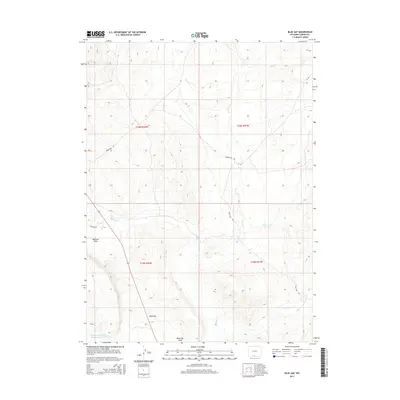
2015 Map of Blue Gap
USGS Topo · Published 2015About this map
Blue Gap serves as a central topographic point in this high-desert region of Carbon County, where a network of seasonal watercourses defines the landscape's drainage patterns. The drainage of Muddy Creek and its tributaries, including Dry Cow Creek and Wild Cow Creek, move through the terrain toward the lower elevations of Mexican Flats. This area is characterized by vast open spaces partitioned by the Public Land Survey System, as seen in the boundaries of Township 16 North, Range 92 West and neighboring townships. Human modification is evident in the water management infrastructure, most notably the Red Gulch Detention Dam 1592 Number 5 at the southwestern edge. Access across these basins is provided by a series of graded routes such as Wamsutter Rd and Standard Rd, which support ranching and local transit through the Blue Gap Draw.
Find a feature on this map
16 named features on this map. Tap any name to fly to it.
Don’t see what you’re looking for? This feature index may not catch every label — zoom into the map to look around manually.
Map Details
Editions of this 2015 Blue Gap Map
This is the sole edition of this map. No revisions or reprints were ever made.
Other maps of this area

1954 · Rawlins
USGS Topo · 1:250,000

1957 · Baggs
USGS Topo · 1:62,500

1957 · Doty Mountain
USGS Topo · 1:62,500

1958 · Rawlins
USGS Topo · 1:250,000

1962 · Rawlins
USGS Topo · 1:250,000

1967 · Rawlins
USGS Topo · 1:250,000

1970 · Mexican Flats
USGS Topo · 1:24,000
1970 · Flat Top Mountain
USGS Topo · 1:24,000

1970 · Duck Lake
USGS Topo · 1:24,000
1975 · Baggs NW
USGS Topo · 1:24,000