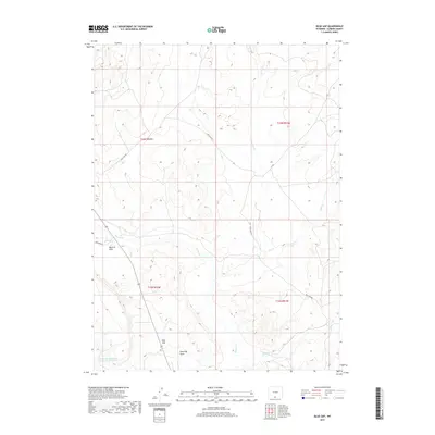
2017 Map of Blue Gap
USGS Topo · Published 2017About this map
Muddy Cr and its various tributaries, including Cow Cr and Dry Cow Cr, define the drainage patterns of this high-desert landscape in Carbon County. The terrain is marked by distinct topographical features like Mexican Flats in the west and the namesake Blue Gap pass further south. This 2017 survey illustrates a network of essential backcountry access routes, such as Wild Cow Rd and Standard Rd, which serve the various township and range sections of this rural territory. Water management in this arid environment is evidenced by the Red Gulch Detention Dam 1592 Number 5 located in the southwestern corner. These labels provide a clear view of the hydrological and logistical infrastructure required to navigate and maintain the open ranges of southern Wyoming.
Find a feature on this map
15 named features on this map. Tap any name to fly to it.
Don’t see what you’re looking for? This feature index may not catch every label — zoom into the map to look around manually.
Map Details
Editions of this 2017 Blue Gap Map
This is the sole edition of this map. No revisions or reprints were ever made.
Other maps of this area

1954 · Rawlins
USGS Topo · 1:250,000

1957 · Baggs
USGS Topo · 1:62,500

1957 · Doty Mountain
USGS Topo · 1:62,500

1958 · Rawlins
USGS Topo · 1:250,000

1962 · Rawlins
USGS Topo · 1:250,000

1967 · Rawlins
USGS Topo · 1:250,000

1970 · Mexican Flats
USGS Topo · 1:24,000
1970 · Flat Top Mountain
USGS Topo · 1:24,000

1970 · Duck Lake
USGS Topo · 1:24,000
1975 · Baggs NW
USGS Topo · 1:24,000