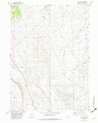
1982 Map of Blue Gap
USGS Topo · Published 1983About this map
Muddy Creek and its seasonal tributaries define this high-desert landscape in Carbon County, Wyoming, during the early 1980s. The region is characterized by extensive energy exploration and resource management, evidenced by numerous infrastructure labels including Gas Wells Well, Flowing Wells, and Soldiers Well. A network of utility corridors and pipelines crosses the terrain, connecting disparate extraction points across the open expanse.
Find a feature on this map
15 named features on this map. Tap any name to fly to it.
Don’t see what you’re looking for? This feature index may not catch every label — zoom into the map to look around manually.
Map Details
Editions of this 1982 Blue Gap Map
This is the sole edition of this map. No revisions or reprints were ever made.
Other maps of this area

1954 · Rawlins
USGS Topo · 1:250,000

1957 · Baggs
USGS Topo · 1:62,500

1957 · Doty Mountain
USGS Topo · 1:62,500

1958 · Rawlins
USGS Topo · 1:250,000

1962 · Rawlins
USGS Topo · 1:250,000

1967 · Rawlins
USGS Topo · 1:250,000

1970 · Mexican Flats
USGS Topo · 1:24,000
1970 · Flat Top Mountain
USGS Topo · 1:24,000

1970 · Duck Lake
USGS Topo · 1:24,000
1975 · Baggs NW
USGS Topo · 1:24,000