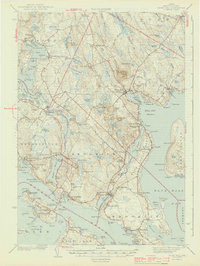
1944 Map of Blue Hill
USGS Topo · Published 1944About this map
The complex shoreline of Penobscot Bay and Blue Hill Bay dominates this coastal survey, where the maritime character of mid-century Hancock County is evident in every cove and peninsula. Along the southern edge, the Deer Isle-Sedgwick Bridge provides a critical link across the Eggemoggin Reach to Little Deer Isle. The interior landscape is marked by prominent elevations like Caterpillar Hill and Wallamatogus Mt, while the settlements of Blue Hill, Brooklin, and Sedgwick serve as the primary hubs for the surrounding rural roads. Local history is deeply embedded in the map's fine details, from the Millstream Mills in the north to small family landmarks like Sargentville and Grays Corner. The distribution of Mt Rest Cem and several community schools, such as Grays Corner Sch, reflects the dispersed but organized settlement pattern typical of the era before modern consolidation.
Find a feature on this map
176 named features on this map. Tap any name to fly to it.
Don’t see what you’re looking for? This feature index may not catch every label — zoom into the map to look around manually.
Map Details
Editions of this 1944 Blue Hill Map
3 editions found

Other maps of this area

1900 · Orland
USGS Topo · 1:62,500

1900 · Bucksport
USGS Topo · 1:62,500

1902 · Bucksport
USGS Topo · 1:62,500

1902 · Castine
USGS Topo · 1:62,500

1904 · Deer Isle
USGS Topo · 1:62,500

1904 · Castine
USGS Topo · 1:62,500

1904 · Mount Desert
USGS Topo · 1:62,500

1904 · Swan Island
USGS Topo · 1:62,500

1904 · Bluehill
USGS Topo · 1:62,500

1904 · Vinalhaven
USGS Topo · 1:62,500