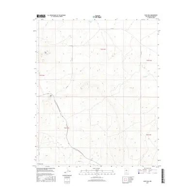
2017 Map of Blue Hills
USGS Topo · Published 2017About this map
The Continental Divide National Scenic Trail winds through this high-elevation landscape in Catron County, tracing the high ridges of the Blue Hills and Taylor Hills. This area is characterized by its vital water management features in an arid environment, including named catchments such as San Antone Lake, Flood Tank, and W Hubbell Tank. The topography is defined by significant drainage systems like McAllister Draw and a network of rural routes such as Co RD a049 and Co RD a082 that provide access through the complex township and range divisions. The mapping reflects the remote, open-range character of western New Mexico, where topographic prominence and water availability dictate the patterns of human movement and land use.
Find a feature on this map
19 named features on this map. Tap any name to fly to it.
Don’t see what you’re looking for? This feature index may not catch every label — zoom into the map to look around manually.
Map Details
Editions of this 2017 Blue Hills Map
This is the sole edition of this map. No revisions or reprints were ever made.
Other maps of this area

1954 · Saint Johns
USGS Topo · 1:250,000

1957 · Saint Johns
USGS Topo · 1:250,000

1958 · Saint Johns
USGS Topo · 1:250,000

1962 · Saint Johns
USGS Topo · 1:250,000

1967 · Omega
USGS Topo · 1:24,000
1967 · Tres Lagunas
USGS Topo · 1:24,000
1967 · York Ranch SE
USGS Topo · 1:24,000
1967 · Red Flats
USGS Topo · 1:24,000

1967 · Adams Diggings
USGS Topo · 1:24,000

1967 · Blue Hills
USGS Topo · 1:24,000