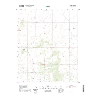
2023 Map of Blue Hills
USGS Topo · Published 2023About this map
Pie Town serves as the primary landmark in this high-altitude corner of Catron County, appearing here as it stands today. The landscape is defined by the Blue Hills and Taylor Hills, characterized by subtle drainages and scattered water sources such as San Antone Lake, Flood Tank, and West Hubbell Tank. These features represent essential infrastructure for ranching and wildlife in a high-desert environment. A significant portion of the western terrain is traversed by the Continental Divide National Scenic Tr, which winds through the rugged ridges and valleys. The map illustrates a contemporary rural grid where modern street names like Sage, Ocaso Cir, and Pinon Ln meet established county thoroughfares such as Co Rd A082 and Co Rd A051.
Find a feature on this map
22 named features on this map. Tap any name to fly to it.
Don’t see what you’re looking for? This feature index may not catch every label — zoom into the map to look around manually.
Map Details
Editions of this 2023 Blue Hills Map
This is the sole edition of this map. No revisions or reprints were ever made.
Other maps of this area

1954 · Saint Johns
USGS Topo · 1:250,000

1957 · Saint Johns
USGS Topo · 1:250,000

1958 · Saint Johns
USGS Topo · 1:250,000

1962 · Saint Johns
USGS Topo · 1:250,000

1967 · Omega
USGS Topo · 1:24,000
1967 · Tres Lagunas
USGS Topo · 1:24,000
1967 · York Ranch SE
USGS Topo · 1:24,000
1967 · Red Flats
USGS Topo · 1:24,000

1967 · Adams Diggings
USGS Topo · 1:24,000

1967 · Blue Hills
USGS Topo · 1:24,000