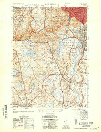
1954 Map of Blue Hills
USGS Topo · Published 1954About this map
Blue Hills Reservation dominates the northern landscape of this mid-century survey, preserving a chain of prominent heights including Great Blue Hill, Chickatawbut Hill, and Nahanton Hill. The presence of the Blue Hill Observatory and the Boston Sch For The Deaf highlights the area's institutional character, while the surrounding towns of Stoughton, Avon, and Randolph show dense suburban development patterns.
Find a feature on this map
116 named features on this map. Tap any name to fly to it.
Don’t see what you’re looking for? This feature index may not catch every label — zoom into the map to look around manually.
Map Details
Editions of this 1954 Blue Hills Map
This is the sole edition of this map. No revisions or reprints were ever made.
Other maps of this area

1885 · Abington
USGS Topo · 1:62,500

1886 · Dedham
USGS Topo · 1:62,500

1888 · Abington
USGS Topo · 1:62,500

1892 · Boston Bay
USGS Topo · 1:62,500

1893 · Abington
USGS Topo · 1:62,500

1893 · Boston
USGS Topo · 1:62,500

1894 · Dedham
USGS Topo · 1:62,500

1903 · Boston
USGS Topo · 1:62,500

1903 · Boston Bay
USGS Topo · 1:62,500

1919 · Dedham
USGS Topo · 1:62,500