
1971 Map of Blue Hills
USGS Topo · Published 1979About this map
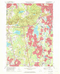
The Blue Hills reservation dominates this 1970s landscape, a significant green space that defines the separation between the southern suburbs and the Boston metropolitan area. The topography is marked by a series of prominent peaks, including Great Blue Hill, Chickatawbut Hill, and Nahanton Hill, which stood as natural barriers to early development. By this era, however, the area is characterized by the heavy infrastructure of the highway age, with numerous interchanges along the southern beltway and the Conrail lines serving the industrial and residential corridors of Quincy, Braintree, and Randolph.
Find a feature on this map
136 named features on this map. Tap any name to fly to it.
Don’t see what you’re looking for? This feature index may not catch every label — zoom into the map to look around manually.
Map Details
Editions of this 1971 Blue Hills Map
2 editions found
Other maps of this area

1885 · Abington
USGS Topo · 1:62,500

1886 · Dedham
USGS Topo · 1:62,500

1888 · Abington
USGS Topo · 1:62,500

1892 · Boston Bay
USGS Topo · 1:62,500

1893 · Abington
USGS Topo · 1:62,500

1893 · Boston
USGS Topo · 1:62,500

1894 · Dedham
USGS Topo · 1:62,500

1903 · Boston
USGS Topo · 1:62,500

1903 · Boston Bay
USGS Topo · 1:62,500

1919 · Dedham
USGS Topo · 1:62,500