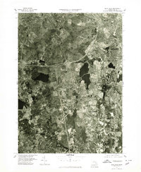
1977 Map of Blue Hills
USGS Topo · Published 1980About this map
The Blue Hills Range dominates the northern landscape of this orthophotoquad, providing a stark visual contrast between the wooded highlands and the expanding residential and commercial footprints of the late 1970s. Produced from aerial photography taken in April 1977, this document captures the southern suburbs of Boston as they integrated into the larger metropolitan network. The dense settlement patterns of Quincy and Braintree are clearly visible, showing the post-war suburban development that defined this era. Farther south, the townships of Randolph, Stoughton, and Avon are depicted with their characteristic mix of local road networks and larger arterial highways. This 1:25,000 scale survey by the U.S. Geological Survey and the Commonwealth of Massachusetts Department of Public Works offers a detailed photographic record of land use, from the forested conservation lands of Milton to the clustered neighborhoods of Holbrook.
Find a feature on this map
9 named features on this map. Tap any name to fly to it.
Don’t see what you’re looking for? This feature index may not catch every label — zoom into the map to look around manually.
Map Details
Editions of this 1977 Blue Hills Map
This is the sole edition of this map. No revisions or reprints were ever made.
Other maps of this area

1885 · Abington
USGS Topo · 1:62,500

1886 · Dedham
USGS Topo · 1:62,500

1888 · Abington
USGS Topo · 1:62,500

1892 · Boston Bay
USGS Topo · 1:62,500

1893 · Abington
USGS Topo · 1:62,500

1893 · Boston
USGS Topo · 1:62,500

1894 · Dedham
USGS Topo · 1:62,500

1903 · Boston
USGS Topo · 1:62,500

1903 · Boston Bay
USGS Topo · 1:62,500

1919 · Dedham
USGS Topo · 1:62,500