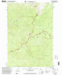
1998 Map of Blue Joint
USGS Topo · Published 2002About this map
The Bitterroot Mountains define this high-altitude landscape along the border of Idaho and Montana, where three major federal preserves meet. This 1998 revision, based on earlier surveys, illustrates the intersection of the Frank Church River of No Return Wilderness, the Bitterroot National Forest, and the Salmon-Challis National Forest. The map is dominated by the steep drainage basins of Blue Joint Creek and French Creek, which flow through heavily dissected terrain. Settlement is absent here, with the only modern infrastructure being the West Fork North Fork Rd entering the northeastern corner. Significant landmarks for backcountry navigation include Squaw Peak, Storm Ridge, and the Blue Joint peak, alongside small alpine features such as Reynolds Lake and Line Lake. The various county and state boundaries shown tracing the ridgelines underscore the isolation of this corner of the interior Northwest.
Find a feature on this map
25 named features on this map. Tap any name to fly to it.
Don’t see what you’re looking for? This feature index may not catch every label — zoom into the map to look around manually.
Map Details
Editions of this 1998 Blue Joint Map
This is the sole edition of this map. No revisions or reprints were ever made.
Other maps of this area

1956 · Elk City
USGS Topo · 1:250,000

1960 · Elk City
USGS Topo · 1:250,000

1960 · Painted Rocks Lake
USGS Topo · 1:62,500

1960 · Shoup
USGS Topo · 1:62,500

1962 · Wood Hump
USGS Topo · 1:24,000

1962 · Beaver Jack Mtn
USGS Topo · 1:24,000

1962 · Blue Joint
USGS Topo · 1:24,000

1962 · Square Top
USGS Topo · 1:24,000

1962 · Horse Creek Butte
USGS Topo · 1:24,000

1962 · Nez Perce Peak
USGS Topo · 1:24,000