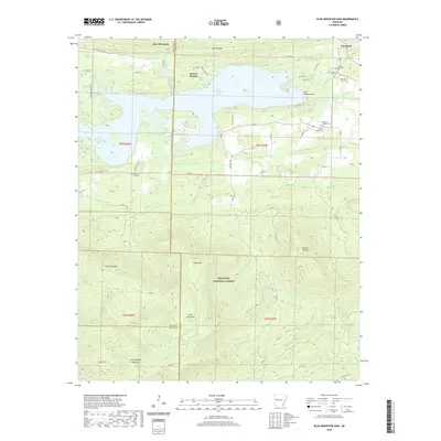
2020 Map of Blue Mountain Dam
USGS Topo · Published 2020About this map
Blue Mountain Lake dominates the northern landscape of this region, held by the massive Blue Mountain Dam along the Petit Jean River. This 2020 map details the transition from the low-lying reservoir area near Quarry Heights and Waveland to the high, forested ridges of the Ouachita National Forest to the south. The terrain is defined by dramatic elevations including Petit Jean Mtn, Flood Mtn, and Dry Creek Mtn, creating a complex network of drainages like Dry Cr and Cedar Cr. For those researching local family history, several burial grounds are identified, including Small Smith Cem, Moores Chapel Cem, and County Line Cem, which sits right on the border of Yell and Logan counties. The road network, including Hog Thief Valley Rd and Quarry Bluff Rd, provides access to both the recreational lakefront and the timbered heights.
Find a feature on this map
63 named features on this map. Tap any name to fly to it.
Don’t see what you’re looking for? This feature index may not catch every label — zoom into the map to look around manually.
Map Details
Editions of this 2020 Blue Mountain Dam Map
This is the sole edition of this map. No revisions or reprints were ever made.
Other maps of this area

1879 · Mountain Home
USGS Topo · 1:62,500

1887 · Magazine Mountain #4
USGS Topo · 1:62,500

1887 · Mount Ida #2
USGS Topo · 1:62,500

1887 · Magazine Mountain #3
USGS Topo · 1:62,500

1887 · Magazine Mountain
USGS Topo · 1:62,500

1890 · Magazine Mountain
USGS Topo · 1:125,000

1890 · Mount Ida
USGS Topo · 1:125,000

1934 · Booneville
USGS Topo · 1:48,000

1939 · Booneville
USGS Topo · 1:62,500

1955 · Little Rock
USGS Topo · 1:250,000