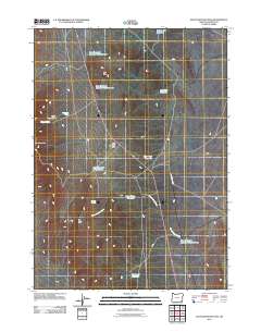
2011 Map of Blue Mountain Pass
USGS Topo · Published 2011About this map
Blue Mountain Pass serves as a central point of this high-desert landscape in Malheur County, where the infrastructure of water management defines the arid terrain. The map reveals an extensive network of reservoirs, including Basque Flat Reservoir, Lone Star Reservoir, and the series of Blue Mountain Reservoir Number One and Blue Mountain Reservoir Number Two. These features, along with Horse Corral Creek, suggest a landscape historically shaped by livestock ranching and the critical need for seasonal water storage. Distinctive geological markers like The Cap and The Table stand out alongside Blue Mountain, while the presence of Blue Mountain Pit Reservoir indicates localized excavation or industrial use. The primary corridor through this remote area is defined by Crooked Creek Rd, connecting these scattered water sources and topographical landmarks.
Find a feature on this map
19 named features on this map. Tap any name to fly to it.
Don’t see what you’re looking for? This feature index may not catch every label — zoom into the map to look around manually.
Map Details
Editions of this 2011 Blue Mountain Pass Map
This is the sole edition of this map. No revisions or reprints were ever made.
Other maps of this area

1955 · Jordan Valley
USGS Topo · 1:250,000

1957 · Jordan Valley
USGS Topo · 1:250,000

1958 · Jordan Valley
USGS Topo · 1:250,000

1982 · Battle Mtn
USGS Topo · 1:24,000
1982 · Oregon Canyon Ranch
USGS Topo · 1:24,000
1982 · Bowden Waterhole
USGS Topo · 1:24,000
1982 · Jackson Summit
USGS Topo · 1:24,000
1982 · Basque
USGS Topo · 1:24,000
1982 · Battle Creek Ranch
USGS Topo · 1:24,000
1982 · Three Man Butte Well
USGS Topo · 1:24,000