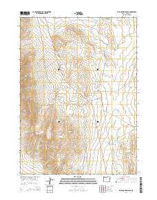
2014 Map of Blue Mountain Pass
USGS Topo · Published 2014About this map
Blue Mountain Pass serves as a central transit point in this high-desert region of Malheur County, where the ION Hwy (Highway 95) bisects the landscape. The geography is defined by a sophisticated network of water management features essential for ranching and land use, including a numbered series of basins such as Blue Mountain Reservoir Number One, Blue Mountain Reservoir Number Two, and Blue Mountain Reservoir Number Five. Significant terrain landmarks like The Cap and The Table rise above the surrounding flats, providing natural navigation points. The map details the seasonal water resources of the area, from Basque Flat Reservoir in the north to Crossroad Reservoir in the south, connected by drainage systems like Horse Corral Cr. This 2014 survey documents the modern infrastructure and remote topography of southeastern Oregon, illustrating how water storage and road networks like the Cascade Spur define human presence in the Great Basin.
Find a feature on this map
27 named features on this map. Tap any name to fly to it.
Don’t see what you’re looking for? This feature index may not catch every label — zoom into the map to look around manually.
Map Details
Editions of this 2014 Blue Mountain Pass Map
This is the sole edition of this map. No revisions or reprints were ever made.
Other maps of this area

1955 · Jordan Valley
USGS Topo · 1:250,000

1957 · Jordan Valley
USGS Topo · 1:250,000

1958 · Jordan Valley
USGS Topo · 1:250,000

1982 · Battle Mtn
USGS Topo · 1:24,000
1982 · Oregon Canyon Ranch
USGS Topo · 1:24,000
1982 · Bowden Waterhole
USGS Topo · 1:24,000
1982 · Jackson Summit
USGS Topo · 1:24,000
1982 · Basque
USGS Topo · 1:24,000
1982 · Battle Creek Ranch
USGS Topo · 1:24,000
1982 · Three Man Butte Well
USGS Topo · 1:24,000