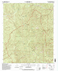
1995 Map of Blue Mountain
USGS Topo · Published 1998About this map
The San Mateo Mountains dominate this high-altitude landscape within the Cibola National Forest, a terrain of steep canyons and isolated peaks. This mid-1990s survey preserves the legend of the Apache Kid Wilderness, explicitly marking the Apache Kid Grave Site near the Apache Kid Peak. The geography is defined by a series of dramatic drainages including Red Canyon and San Mateo Canyon, separated by prominent ridges such as Skeleton Ridge and Bull Saddle. Water sources are critical but scattered, documented here through numerous remote springs like Hardscrabble Spring, Old Hidden Spring, and Indian Spring. The map traces a complex network of pack trails and fire breaks, including the long Wilderness Boundary and the Drift Fence Canyon road, reflecting the area's management for conservation and its storied history of outlaws and early western lore.
Find a feature on this map
48 named features on this map. Tap any name to fly to it.
Don’t see what you’re looking for? This feature index may not catch every label — zoom into the map to look around manually.
Map Details
Editions of this 1995 Blue Mountain Map
This is the sole edition of this map. No revisions or reprints were ever made.
Other maps of this area

1954 · Tularosa
USGS Topo · 1:250,000

1958 · Tularosa
USGS Topo · 1:250,000

1964 · Welty Hill
USGS Topo · 1:24,000

1964 · Vicks Peak
USGS Topo · 1:24,000

1964 · San Juan Peak
USGS Topo · 1:24,000

1964 · Bay Buck Peaks
USGS Topo · 1:24,000

1964 · Blue Mountain
USGS Topo · 1:24,000

1964 · Montoya Butte
USGS Topo · 1:24,000

1964 · Steel Hill
USGS Topo · 1:24,000
1964 · Grassy Lookout
USGS Topo · 1:24,000