
1964 Map of Steel Hill
USGS Topo · Published 1966About this map
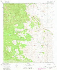
Cibola National Forest dominates the western half of this mid-century New Mexico landscape, where the wooded high ground of Spruce Park gives way to a network of drainage systems. The map illustrates a transitional zone between the high elevations and the lower eastern plains, defined by prominent landmarks like Steel Hill and Bell Hill. Human activity is sparse but specific, concentrated at the Nogal Canyon Ranch and a nearby Landing Field at the mouth of Nogal Canyon. Resource extraction is evidenced by the Picky Mine located in the northwest, while water sources like Rabbit Spring and Deer Springs Canyon were critical anchors in this arid environment. The intricate contour lines detail the complex terrain of Cerra de las Cabras and the winding course of the San Jose Arroyo, reflecting the remote ranching and mining character of Socorro County during the 1960s.
Find a feature on this map
21 named features on this map. Tap any name to fly to it.
Don’t see what you’re looking for? This feature index may not catch every label — zoom into the map to look around manually.
Map Details
Editions of this 1964 Steel Hill Map
2 editions found
Other maps of this area

1954 · Tularosa
USGS Topo · 1:250,000

1958 · Tularosa
USGS Topo · 1:250,000

1961 · Sierra Fijardo
USGS Topo · 1:24,000

1961 · Hickman Ranch
USGS Topo · 1:24,000

1961 · Black Hill
USGS Topo · 1:24,000

1961 · Monticello
USGS Topo · 1:24,000

1961 · Romero Canyon
USGS Topo · 1:24,000

1964 · Vicks Peak
USGS Topo · 1:24,000

1964 · San Juan Peak
USGS Topo · 1:24,000

1964 · Blue Mountain
USGS Topo · 1:24,000