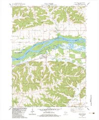
1983 Map of Blue River
USGS Topo · Published 1983About this map
The Wisconsin River dominates the landscape at the border of Richland Co and Grant Co, carving a wide valley filled with intricate water features like Cross Slough and Garner Lake. The settlement of Blue River sits on the southern bank, positioned near the Wisconsin Western railroad line. North of the water, the village of Port Andrew rests near the base of Strawberry Ridge, illustrating the historical reliance on river-bottom flats for early Wisconsin development.
Find a feature on this map
34 named features on this map. Tap any name to fly to it.
Don’t see what you’re looking for? This feature index may not catch every label — zoom into the map to look around manually.
Map Details
Editions of this 1983 Blue River Map
This is the sole edition of this map. No revisions or reprints were ever made.
Other maps of this area

1905 · Richland Center
USGS Topo · 1:125,000

1933 · Boaz
USGS Topo · 1:62,500

1933 · Boscobel
USGS Topo · 1:62,500

1958 · La Crosse
USGS Topo · 1:250,000

1960 · Richland Center
USGS Topo · 1:62,500

1960 · Muscoda
USGS Topo · 1:62,500

1961 · La Crosse
USGS Topo · 1:250,000

1965 · La Crosse
USGS Topo · 1:250,000

1966 · Boaz
USGS Topo · 1:62,500
1967 · Boscobel
USGS Topo · 1:62,500