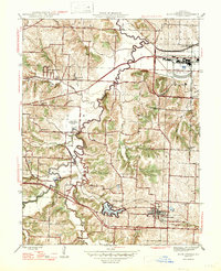
1947 Map of Blue Springs
USGS Topo · Published 1947About this map
The Little Blue River and its meanders define the landscape of Jackson County in the mid-1940s, a period when the area was transitioning from rural farming communities to an industrial and suburban corridor. The massive Lake City Ordnance Plant stands as a significant military-industrial landmark in the northeast, contrasted by the developing recreational and residential presence at Lake Tapawingo. Local educational and spiritual life is well-documented through numerous rural institutions, including the Old Blue Springs Sch, Eureka Sch, and Pleasant Grove Ch. Transportation networks are dominated by the Chicago and Alton and Pacific railroads, which facilitated growth in settlements like Blue Springs, Selsa, and East Independence. The map also captures the Lake Port Independence Airport and several family-named roads such as Owens Road and Mize Road, reflecting the deeply rooted local history of the Fort Osage region.
Find a feature on this map
38 named features on this map. Tap any name to fly to it.
Don’t see what you’re looking for? This feature index may not catch every label — zoom into the map to look around manually.
Map Details
Editions of this 1947 Blue Springs Map
2 editions found
Other maps of this area

1887 · Harrisonville
USGS Topo · 1:125,000

1892 · Harrisonville
USGS Topo · 1:125,000

1894 · Harrisonville
USGS Topo · 1:125,000

1894 · Independence
USGS Topo · 1:125,000

1933 · Blue Springs
USGS Topo · 1:24,000

1934 · Oak Grove
USGS Topo · 1:24,000

1934 · Independence
USGS Topo · 1:24,000

1934 · Lees Summit
USGS Topo · 1:24,000

1934 · Woods Chapel
USGS Topo · 1:24,000

1935 · Buckner
USGS Topo · 1:24,000