1981 Map of Bluefield
USGS Topo · Published 1988About this map
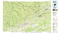
Bluefield and Princeton anchor this rugged Appalachian survey, where the West Virginia - Virginia State Line cuts through a dense landscape of ridges and river valleys. The region's industrial and coal heritage is visible in the network of the Norfolk and Western Railway and the Chesapeake and Ohio Railway connecting towns like Welch, Coalwood, and Richlands. A unique geological feature, the high mountain valley of Burkes Garden, is enclosed by Garden Mountain, contrasting with the linear stretches of East River Mountain and Stony Ridge.
Find a feature on this map
201 named features on this map. Tap any name to fly to it.
Don’t see what you’re looking for? This feature index may not catch every label — zoom into the map to look around manually.
Map Details
Editions of this 1981 Bluefield Map
2 editions found

Other maps of this area

1886 · Grundy
USGS Topo · 1:125,000

1887 · Warfield
USGS Topo · 1:125,000

1887 · Pocahontas
USGS Topo · 1:125,000

1887 · Hinton
USGS Topo · 1:125,000

1889 · Hillsville
USGS Topo · 1:125,000

1889 · Wytheville
USGS Topo · 1:125,000

1890 · Grundy
USGS Topo · 1:125,000

1890 · Dublin
USGS Topo · 1:125,000

1891 · Tazewell
USGS Topo · 1:125,000

1891 · Pocahontas
USGS Topo · 1:125,000