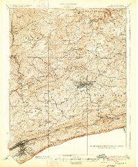
1926 Map of Bluefield
USGS Topo · Published 1926About this map
The Bluestone River and its numerous tributaries carve through the heart of Mercer County in the mid-1920s, a period when the local economy was anchored by heavy rail and mountain agriculture. The corridor between Bluefield and Princeton shows a dense network of country schools like the Stinson School and Cedar Cliff School, reflecting a settled rural population before the consolidation of the late 20th century. The presence of the Norfolk and Western Ry and the Virginian RR, along with specialized infrastructure like the Lumber RR, underscores the region's role in the timber and coal trade.
Find a feature on this map
120 named features on this map. Tap any name to fly to it.
Don’t see what you’re looking for? This feature index may not catch every label — zoom into the map to look around manually.
Map Details
Editions of this 1926 Bluefield Map
3 editions found
Other maps of this area

1887 · Pocahontas
USGS Topo · 1:125,000

1887 · Hinton
USGS Topo · 1:125,000

1890 · Dublin
USGS Topo · 1:125,000

1891 · Pocahontas
USGS Topo · 1:125,000

1891 · Dublin
USGS Topo · 1:125,000

1891 · Raleigh
USGS Topo · 1:125,000

1892 · Hinton
USGS Topo · 1:125,000

1894 · Pocahontas
USGS Topo · 1:125,000

1895 · Pocahontas
USGS Topo · 1:125,000

1897 · Raleigh
USGS Topo · 1:125,000