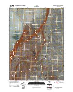
2011 Map of Bluejoint Lake East
USGS Topo · Published 2011About this map
Hart Mountain Antelope Refuge dominates the high desert landscape of Harney County, encompassing a vast territory of protected sagebrush and wildlife habitat. The eastern shoreline of Bluejoint Lake occupies the western edge of the quadrangle, where the intermittent water levels of the Great Basin are evident in the sprawling playa terrain. Drainage throughout the area is defined by the winding course of Rock Creek, which cuts through the arid plains before passing near the topographical relief of Snyder Canyon. This 2011 survey illustrates a sparsely developed region of southeastern Oregon where primitive roads and natural watercourses remain the primary landmarks, reflecting the enduring character of the high desert wilderness.
Find a feature on this map
4 named features on this map. Tap any name to fly to it.
Don’t see what you’re looking for? This feature index may not catch every label — zoom into the map to look around manually.
Map Details
Editions of this 2011 Bluejoint Lake East Map
This is the sole edition of this map. No revisions or reprints were ever made.
Other maps of this area

1955 · Adel
USGS Topo · 1:250,000

1957 · Adel
USGS Topo · 1:250,000

1958 · Adel
USGS Topo · 1:250,000

1962 · Adel
USGS Topo · 1:250,000

1966 · Bluejoint Lake East
USGS Topo · 1:24,000

1967 · Campbell Lake
USGS Topo · 1:24,000

1967 · Flook Lake
USGS Topo · 1:24,000

1967 · Bluejoint Lake West
USGS Topo · 1:24,000

1971 · Steamboat Point
USGS Topo · 1:24,000

1971 · Murphy Waterholes
USGS Topo · 1:24,000