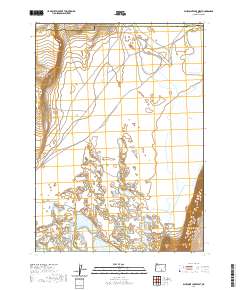
2020 Map of Bluejoint Lake West
USGS Topo · Published 2020About this map
Warner Valley forms the basin for this remote section of the Oregon high desert, where seasonal hydrology dictates the landscape. The map centers on the expansive and marshy bed of Bluejoint Lake, a terminal lake system that fluctuates with the regional water table. To the west, the dramatic uplift of Poker Jim Ridge creates a prominent topographical boundary, rising sharply from the valley floor. The desert floor is punctuated by smaller ephemeral water bodies, including Turpin Lake and the notably named Stone Corral Lake, which suggests a history of livestock management and early ranching infrastructure in this arid environment. The boundary between Harney and Lake counties runs along the northern edge of this survey, marking a significant administrative line through the largely uninhabited terrain.
Find a feature on this map
11 named features on this map. Tap any name to fly to it.
Don’t see what you’re looking for? This feature index may not catch every label — zoom into the map to look around manually.
Map Details
Editions of this 2020 Bluejoint Lake West Map
This is the sole edition of this map. No revisions or reprints were ever made.
Other maps of this area

1955 · Adel
USGS Topo · 1:250,000

1957 · Adel
USGS Topo · 1:250,000

1958 · Adel
USGS Topo · 1:250,000

1962 · Adel
USGS Topo · 1:250,000

1966 · Bluejoint Lake East
USGS Topo · 1:24,000

1966 · Rabbit Hills NE
USGS Topo · 1:24,000

1967 · Flagstaff Lake
USGS Topo · 1:24,000

1967 · Campbell Lake
USGS Topo · 1:24,000

1967 · Flook Lake
USGS Topo · 1:24,000

1967 · Bluejoint Lake West
USGS Topo · 1:24,000