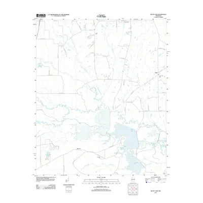
2012 Map of Bluff Lake
USGS Topo · Published 2012About this map
Bluff Lake and the surrounding wetlands dominate the southern half of this landscape, where the Noxubee River and Loakfoma Cr feed into a complex hydrologic system. In this region of Mississippi, the terrain transitions from agricultural fields and rural homesteads in the north, near Oktoc, to the dense riparian environments of the Griffin Slough and Pete Slough. The presence of several established burial grounds, including the Bethel Cem and White Cem, suggests a long-standing rural community structure centered around family and church sites.
Find a feature on this map
68 named features on this map. Tap any name to fly to it.
Don’t see what you’re looking for? This feature index may not catch every label — zoom into the map to look around manually.
Map Details
Editions of this 2012 Bluff Lake Map
This is the sole edition of this map. No revisions or reprints were ever made.
Other maps of this area

1953 · West Point
USGS Topo · 1:250,000

1958 · West Point
USGS Topo · 1:250,000

1959 · Artesia
USGS Topo · 1:62,500

1963 · West Point
USGS Topo · 1:250,000

1965 · Starkville
USGS Topo · 1:24,000

1965 · Bluff Lake
USGS Topo · 1:24,000

1965 · Longview
USGS Topo · 1:24,000

1965 · Bradley
USGS Topo · 1:24,000
1973 · Barge Lake
USGS Topo · 1:24,000
1973 · Betheden
USGS Topo · 1:24,000