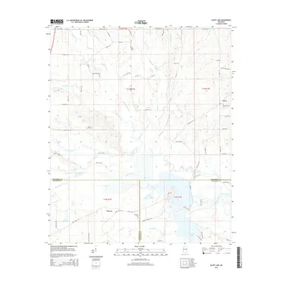
2015 Map of Bluff Lake
USGS Topo · Published 2015About this map
Bluff Lake and Loakfoma Lake dominate the southern wetlands of this Mississippi landscape, marking a complex drainage system where the Noxubee River and Oktoc Creek converge. The terrain is defined by an intricate network of waterways, including Griffin Slough, Pete Slough, and the Jordan Canal, which illustrate the managed hydrology of the region near the boundary of Oktibbeha, Winston, and Noxubee counties. Rural life is centered around small settlements like Oktoc and Winston, with local history preserved in scattered burial sites such as Bethel Cemetery, Cedar Grove Cemetery, and Noxubee Cemetery. The presence of numerous family-named landmarks, such as the areas associated with Henry Sansing, alongside creeks with evocative names like Tobacco Juice Creek and Talking Warrior Creek, provides a detailed view of the local geography and land ownership patterns that have persisted into the 21st century.
Find a feature on this map
77 named features on this map. Tap any name to fly to it.
Don’t see what you’re looking for? This feature index may not catch every label — zoom into the map to look around manually.
Map Details
Editions of this 2015 Bluff Lake Map
This is the sole edition of this map. No revisions or reprints were ever made.
Other maps of this area

1953 · West Point
USGS Topo · 1:250,000

1958 · West Point
USGS Topo · 1:250,000

1959 · Artesia
USGS Topo · 1:62,500

1963 · West Point
USGS Topo · 1:250,000

1965 · Starkville
USGS Topo · 1:24,000

1965 · Bluff Lake
USGS Topo · 1:24,000

1965 · Longview
USGS Topo · 1:24,000

1965 · Bradley
USGS Topo · 1:24,000
1973 · Barge Lake
USGS Topo · 1:24,000
1973 · Betheden
USGS Topo · 1:24,000