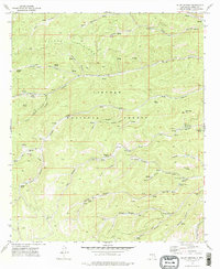
1974 Map of Bluff Springs
USGS Topo · Published 1978About this map
Lincoln National Forest topography defines this high-elevation landscape, where the headwaters of the Rio Peñasco and Agua Chiquita Canyon carve through a network of steep ridges and timbered draws. Traces of historical industry and transportation remain visible through the Old Railroad Grade winding through Willie Canyon and Wills Canyon, marking former timber or ranching routes. The area is notable for its high density of named water sources, including Bluff Springs, Charles Spring, and Hubbell Spring, which likely served as critical landmarks for early ranching operations. Human presence in the mid-1970s is indicated by recreational sites like Camp Wehinahpay, Pine Springs Camp, and Skyridge Camp, alongside specialized features such as a Heliport and a Picnic Area. Family-named landmarks like Prestridge Hill and Masterson Spring offer specific touchpoints for local genealogical research in this mountain terrain.
Find a feature on this map
50 named features on this map. Tap any name to fly to it.
Don’t see what you’re looking for? This feature index may not catch every label — zoom into the map to look around manually.
Map Details
Editions of this 1974 Bluff Springs Map
This is the sole edition of this map. No revisions or reprints were ever made.
Other maps of this area

1950 · Escondido Canyon
USGS Topo · 1:62,500

1950 · Alamogordo
USGS Topo · 1:62,500

1952 · Cloudcroft
USGS Topo · 1:62,500

1954 · Carlsbad
USGS Topo · 1:250,000

1958 · Carlsbad
USGS Topo · 1:250,000

1965 · Bear Spring
USGS Topo · 1:24,000

1965 · Rogers Ruins
USGS Topo · 1:24,000
1974 · Sacramento
USGS Topo · 1:24,000
1974 · Harvey Ranch
USGS Topo · 1:24,000
1977 · Cloudcroft
USGS Topo · 1:24,000