
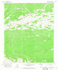
1965 Map of Bear Spring
USGS Topo · Published 1968About this map
Lincoln National Forest land dominates this mid-1960s survey of the high-elevation New Mexico backcountry. The landscape is defined by an intricate network of deep drainages, including Sleepy Grass Canyon and Jim Lewis Canyon, where early habitation and livestock management are evidenced by the Jeffers Cem and several water improvements like Lick Tank. The rugged geography necessitated the Garnisa Lookout Tower for fire observation over the surrounding timber. Family names are etched into the terrain through landmarks such as McEwan Spring and Jeffers Spring. Perennial water sources were vital in this environment, with Bluewater Creek and the namesake Bear Spring providing essential resources in a region otherwise marked by seasonal runoff and steep ridgelines like Lick Ridge.
Find a feature on this map
32 named features on this map. Tap any name to fly to it.
Don’t see what you’re looking for? This feature index may not catch every label — zoom into the map to look around manually.
Map Details
Editions of this 1965 Bear Spring Map
2 editions found
Other maps of this area

1952 · Cloudcroft
USGS Topo · 1:62,500

1954 · Carlsbad
USGS Topo · 1:250,000

1958 · Carlsbad
USGS Topo · 1:250,000

1963 · Woodson Canyon
USGS Topo · 1:24,000

1965 · Surveyors Canyon
USGS Topo · 1:24,000

1965 · Avis
USGS Topo · 1:24,000

1965 · Rogers Ruins
USGS Topo · 1:24,000

1965 · El Paso Canyon
USGS Topo · 1:24,000

1965 · Pinon
USGS Topo · 1:24,000
1974 · Sacramento
USGS Topo · 1:24,000