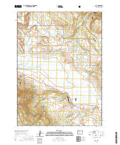
2020 Map of Bly
USGS Topo · Published 2020About this map
The high-desert settlement of Bly sits at a critical junction where the Sprague River watershed gathers from several mountain forks. This landscape is defined by the hydrologic transition from upland volcanic features like Round Butte and Bly Ridge to the broad, marshy bottoms of Leonard Slough and Gayheart Slough. Much of the territory is managed as part of the Fremont National Forest, illustrating the region's reliance on timber and grazing lands. The map details a complex network of forest roads and irrigation infrastructure, including the N Fork Ditch and Elder Ditch, which redirect water across the flats for agricultural use. Aviation footprints are visible through Allen's Airstrip and Anderson Field, serving this remote corner of Klamath County. Local landmarks like Whiskey John Flat and The Elbow mark the distinctive terrain of the Fremont Highlands.
Find a feature on this map
50 named features on this map. Tap any name to fly to it.
Don’t see what you’re looking for? This feature index may not catch every label — zoom into the map to look around manually.
Map Details
Editions of this 2020 Bly Map
This is the sole edition of this map. No revisions or reprints were ever made.
Other maps of this area

1889 · Klamath
USGS Topo · 1:250,000

1894 · Klamath
USGS Topo · 1:250,000

1955 · Klamath Falls
USGS Topo · 1:250,000

1958 · Klamath Falls
USGS Topo · 1:250,000

1960 · Riverbed Butte
USGS Topo · 1:62,500

1960 · Bly
USGS Topo · 1:62,500

1960 · Fishhole Mtn
USGS Topo · 1:62,500

1966 · Sandhill Crossing
USGS Topo · 1:24,000

1974 · Lake Abert
USGS Topo · 1:100,000

1975 · Lakeview
USGS Topo · 1:100,000