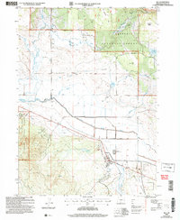
2004 Map of Bly
USGS Topo · Published 2007About this map
The community of Bly serves as the focal point of this survey, situated where the Sprague River watershed meets the timberlands of the Fremont National Forest. Evidence of the region’s industrial history is preserved through labels for the Ivory Pine Mill (Site) and Garner (Site), indicating the shifting footprint of the local timber economy. The landscape is defined by the hydrologic network of the North Fork Sprague River and the South Fork Sprague River, which meander through wide valleys protected by an extensive system of Levees. To the south, the topography rises sharply toward Bly Ridge and the volcanic expanse of Devils Garden. This detailed rendering shows the infrastructure of the early 2000s, from the local Landing Strip and Sewage Disposal Ponds to various water management features like Whitmore Reservoir and Obenhain Reservoir.
Find a feature on this map
36 named features on this map. Tap any name to fly to it.
Don’t see what you’re looking for? This feature index may not catch every label — zoom into the map to look around manually.
Map Details
Editions of this 2004 Bly Map
This is the sole edition of this map. No revisions or reprints were ever made.
Other maps of this area

1889 · Klamath
USGS Topo · 1:250,000

1894 · Klamath
USGS Topo · 1:250,000

1955 · Klamath Falls
USGS Topo · 1:250,000

1958 · Klamath Falls
USGS Topo · 1:250,000

1960 · Riverbed Butte
USGS Topo · 1:62,500

1960 · Bly
USGS Topo · 1:62,500

1960 · Fishhole Mtn
USGS Topo · 1:62,500

1966 · Sandhill Crossing
USGS Topo · 1:24,000

1974 · Lake Abert
USGS Topo · 1:100,000

1975 · Lakeview
USGS Topo · 1:100,000