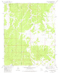
1980 Map of Blye Canyon NE
USGS Topo · Published 1980About this map
The Hualapai Indian Reservation defines the northern edge of this high desert terrain, where the landscape is marked by deep drainage systems like Blye Canyon and Nelson Canyon. In a region where water is the primary constraint, the map records a dense network of specialized stock tanks and water catchments vital to the local cattle industry. Names like Red Rock Tank, North Iron Gate Tank, and South Iron Gate Tank reflect the ranching geography of the late 20th century.
Find a feature on this map
27 named features on this map. Tap any name to fly to it.
Don’t see what you’re looking for? This feature index may not catch every label — zoom into the map to look around manually.
Map Details
Editions of this 1980 Blye Canyon NE Map
This is the sole edition of this map. No revisions or reprints were ever made.
Other maps of this area

1886 · Diamond Creek
USGS Topo · 1:250,000

1892 · Diamond Creek
USGS Topo · 1:250,000

1948 · Williams
USGS Topo · 1:250,000

1954 · Williams
USGS Topo · 1:250,000

1956 · Williams
USGS Topo · 1:250,000

1960 · Williams
USGS Topo · 1:250,000

1961 · Williams
USGS Topo · 1:250,000

1967 · Peach Springs
USGS Topo · 1:24,000
1967 · Nelson
USGS Topo · 1:24,000
1980 · Cherokee Point
USGS Topo · 1:24,000