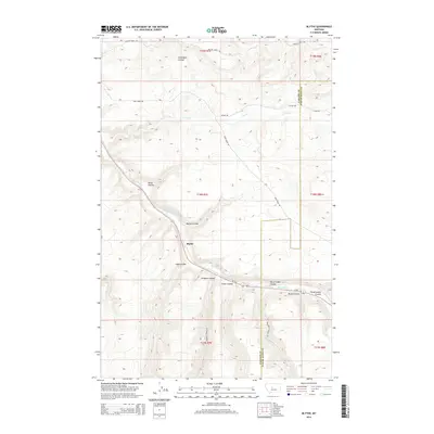
2014 Map of Blythe
USGS Topo · Published 2014About this map
Blythe sits at the junction of several drainage systems in the central Montana landscape, where the high plains are deeply dissected by numerous coulees. This 2014 survey illustrates a rugged ranching and agricultural environment characterized by steep-sided draws and seasonal watercourses. The drainage of Big Otter Cr serves as a primary geographical anchor, receiving flow from a series of local landmarks including Baker Coulee, Marion Coulee, and Ford Coulee. The map also captures the administrative boundary between Cascade County and Judith Basin County, a line that cuts across the prairie terrain. Transportation through these uplands is managed via a network of rural routes such as Willow Creek Rd and Geyser Rd, which connect isolated homesteads and grazing lands to the primary corridors of MT-200 and Us-87. Significant local features like Never Sweat Coulee and Government Coulee highlight the unique naming conventions of the region's topography.
Find a feature on this map
28 named features on this map. Tap any name to fly to it.
Don’t see what you’re looking for? This feature index may not catch every label — zoom into the map to look around manually.
Map Details
Editions of this 2014 Blythe Map
This is the sole edition of this map. No revisions or reprints were ever made.
Other maps of this area

1890 · Fort Benton
USGS Topo · 1:250,000

1892 · Fort Benton
USGS Topo · 1:250,000

1897 · Fort Benton
USGS Topo · 1:250,000

1954 · Great Falls
USGS Topo · 1:250,000

1956 · Belt
USGS Topo · 1:62,500

1957 · Great Falls
USGS Topo · 1:250,000
1961 · Limestone Butte
USGS Topo · 1:24,000

1961 · Barker
USGS Topo · 1:62,500
1967 · Monarch NE
USGS Topo · 1:24,000
1967 · Riceville
USGS Topo · 1:24,000